Cocking Tor
| Status | Very sensitive |
| Status Message | Cocking Tor is a particularly sensitive site, reliant on close liason between the club and the neighbouring land-users in order for flying to continue. All potential flyers must please contact the club’s site officer for this site before flying here. Currently this is Ash Ghinn, who’s contact details can be found lower down this page. |
| Wind | NE |
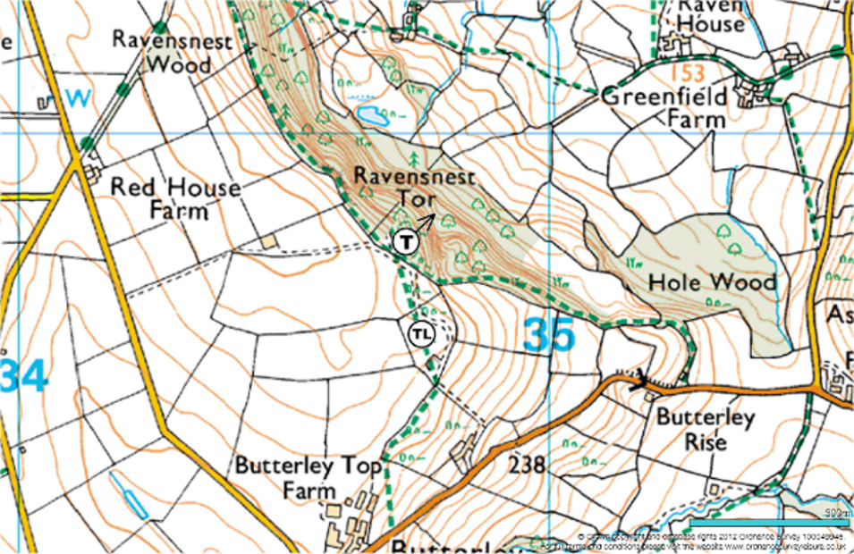
| Take Off | SK 347 607 |
| Top Landing | SK 347 606 |
| Bottom Landing | None agreed, limited options – see the main text. |
| Airspace | 5500 feet Class D. Cross country flights in a NNE wind give an opportunity to negotiate both East Midlands and Manchester airspace and creates the potential for flights to Wales. |
| Location | Amber Valley |
Characteristics
Although widely referred to as Cocking Tor, this site is more accurately described as Ravensnest Tor. Cocking Tor itself is located about 1km north of the current site. It is a rocky outcrop historically used by hang gliders but now overgrown and disused. This site guide exclusively refers to the launch area at Ravensnest Tor.
The site is a hazardous, tree-covered 300-foot rocky ridge which requires a committed launch. It is not usually suitable for ridge soaring and tends to be used by commited cross country pilots willing to take some risk due to the good XC potential. The take-off area is a rough mixture of grass, bracken and brambles, and immediately behind take off is a bench and a (barbed-wire topped) dry stone wall. It is recommended that pilots assess the true wind speed and direction from the area marked as Top Landing, as the airflow at launch is often gusty and actual wind hard to determine. Large trees immediately to the North of take-off create turbulence when the wind is to the North of NE, and trees below and to the East tend to upset airflow in other wind directions. Ravensnest Tor does seem to be a good thermal trigger. Buzzards inhabit this area and can often be seen thermalling immediately in front of take-off. Waiting for clear signs of a thermal is the best way to launch and affords some certainty of gaining a safe height in the shortest possible time.
Bottom Landing
The residents and landowners occupying the bottom fields seem to treasure their privacy and there is no agreed bottom landing. Avoid horses. The lower fields offer sub-optimal landing options due to their limited size, the undulating terrain and the presence of large trees. This may not be immediately apparent from the top of the hill, so it is strongly advised that pilots investigate bottom landing options personally before deciding to fly.
Special rules
Visiting pilots must make contact with the site officer or another DSC representative before flying this site.
Site Officer
Ash Ghinn

Parking
There are no public car parking spaces or lay-byes nearby, and the roads are narrow. If parking on verges make sure you do not obstruct the roads. We have permission from the owners of the farm (located 300m West of take-off) to park on their land adjacent to take off.
Access
If the metal farm gate on Holestone Gate Road is open, pilots may drive through the farm to the take off area. Please make yourself known to anyone working in the farmyard as you drive through. Continue down the track past the launch area and park on the left immediately before entering the “Top Landing” field. If not using the route via the farm, alternative access to launch can be made by taking the public footpath near Butterley Top Farm about a mile East of Tansley on the B6014. This footpath passes right through the launch area.
Photos and Videos from the site
Site Records
Paragliding

Open Distance
Distance :	163.4km
Date :	10/06/2015
Pilot :	Neil Furmidge
Notes :
Tracklog :	xcleague link

Hang Gliding
No hang-gliding records are currently known for this site


